A new landmark detection approach for slam algorithm applied in mobile robot
Mobile robots have received much attention in
recent years due to their potential application in many
fields, for example, logistics, exploration of hazardous
environments, self-driving cars and services [1].
Research topics on mobile robots cover a wide range
of technologies including, navigation, perception,
learning, cooperation, acting, interaction, robot
development, planning, and reasoning. For the task of
navigation, the robot must know the map of
environments and its position simultaneously. This
technique is called SLAM – Simultaneous
Localization and Mapping.
The SLAM contains the simultaneous estimation
of the state of a robot equipped with onboard sensors,
and the generation of a model (the map) of the
environment that the sensors are perceiving. In simple
instances, the robot state is described by its pose
(position and orientation), although other quantities
may be included in the state, such as robot velocity,
sensor biases, and calibration parameters. The map, on
the other hand, is a representation of aspects of interest
(e.g., position of landmarks, obstacles) describing the
environment in which the robot operates [1].
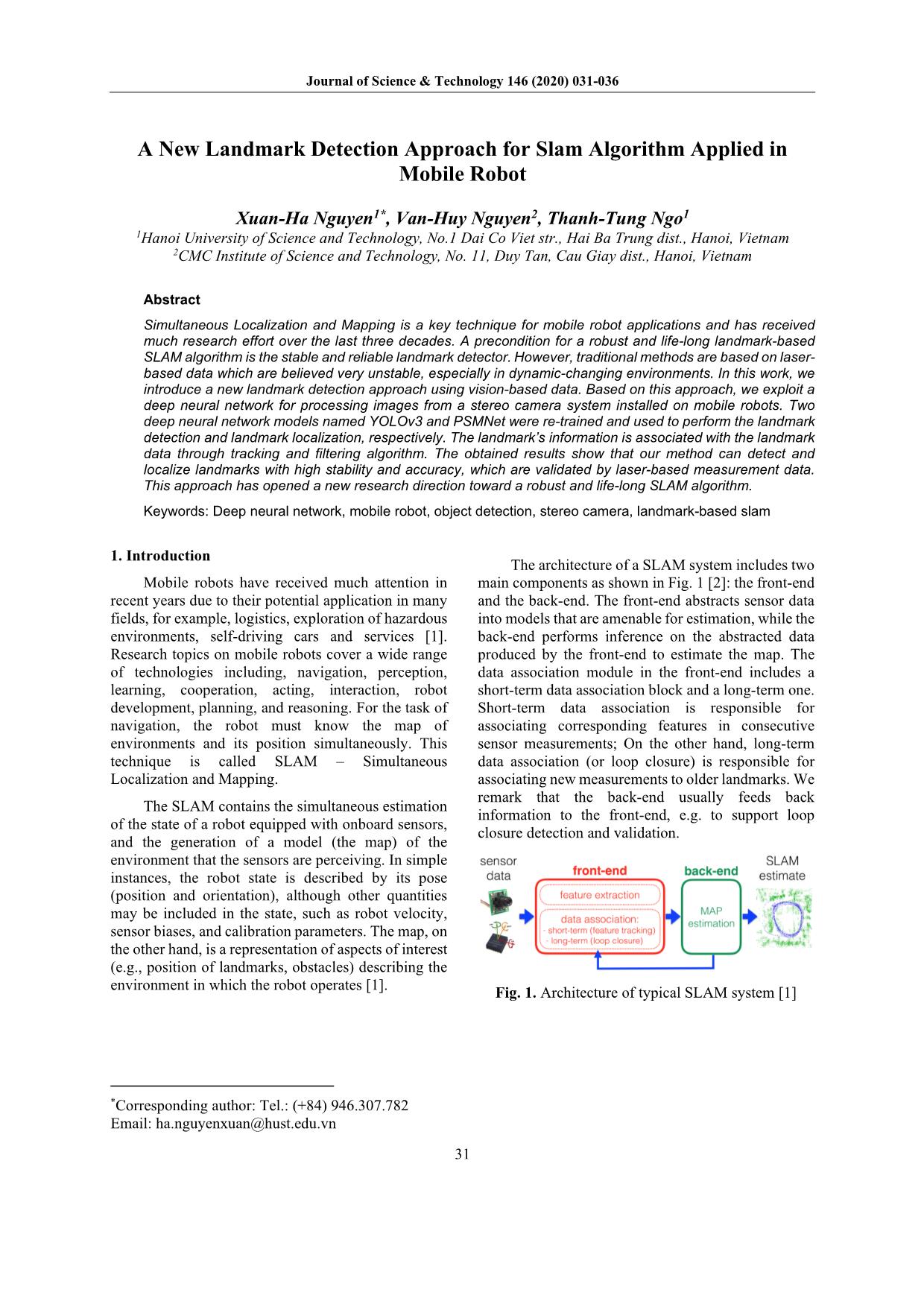
The architecture of a SLAM system includes two
main components as shown in Fig. 1 [2]: the front-end
and the back-end. The front-end abstracts sensor data
into models that are amenable for estimation, while the
back-end performs inference on the abstracted data
produced by the front-end to estimate the map. The
data association module in the front-end includes a
short-term data association block and a long-term one.
Short-term data association is responsible for
associating corresponding features in consecutive
sensor measurements; On the other hand, long-term
data association (or loop closure) is responsible for
associating new measurements to older landmarks. We
remark that the back-end usually feeds back
information to the front-end, e.g. to support loop
closure detection and validation.
Trang 1
Trang 2
Trang 3
Trang 4
Trang 5
Trang 6
Tóm tắt nội dung tài liệu: A new landmark detection approach for slam algorithm applied in mobile robot
Journal of Science & Technology 146 (2020) 031-036
31
A New Landmark Detection Approach for Slam Algorithm Applied in
Mobile Robot
Xuan-Ha Nguyen1*, Van-Huy Nguyen2, Thanh-Tung Ngo1
1Hanoi University of Science and Technology, No.1 Dai Co Viet str., Hai Ba Trung dist., Hanoi, Vietnam
2CMC Institute of Science and Technology, No. 11, Duy Tan, Cau Giay dist., Hanoi, Vietnam
Abstract
Simultaneous Localization and Mapping is a key technique for mobile robot applications and has received
much research effort over the last three decades. A precondition for a robust and life-long landmark-based
SLAM algorithm is the stable and reliable landmark detector. However, traditional methods are based on laser-
based data which are believed very unstable, especially in dynamic-changing environments. In this work, we
introduce a new landmark detection approach using vision-based data. Based on this approach, we exploit a
deep neural network for processing images from a stereo camera system installed on mobile robots. Two
deep neural network models named YOLOv3 and PSMNet were re-trained and used to perform the landmark
detection and landmark localization, respectively. The landmark’s information is associated with the landmark
data through tracking and filtering algorithm. The obtained results show that our method can detect and
localize landmarks with high stability and accuracy, which are validated by laser-based measurement data.
This approach has opened a new research direction toward a robust and life-long SLAM algorithm.
Keywords: Deep neural network, mobile robot, object detection, stereo camera, landmark-based slam
1. Introduction1
Mobile robots have received much attention in
recent years due to their potential application in many
fields, for example, logistics, exploration of hazardous
environments, self-driving cars and services [1].
Research topics on mobile robots cover a wide range
of technologies including, navigation, perception,
learning, cooperation, acting, interaction, robot
development, planning, and reasoning. For the task of
navigation, the robot must know the map of
environments and its position simultaneously. This
technique is called SLAM – Simultaneous
Localization and Mapping.
The SLAM contains the simultaneous estimation
of the state of a robot equipped with onboard sensors,
and the generation of a model (the map) of the
environment that the sensors are perceiving. In simple
instances, the robot state is described by its pose
(position and orientation), although other quantities
may be included in the state, such as robot velocity,
sensor biases, and calibration parameters. The map, on
the other hand, is a representation of aspects of interest
(e.g., position of landmarks, obstacles) describing the
environment in which the robot operates [1].
The architecture of a SLAM system includes two
main components as shown in Fig. 1 [2]: the front-end
and the back-end. The front-end abstracts sensor data
into models that are amenable for estimation, while the
back-end performs inference on the abstracted data
produced by the front-end to estimate the map. The
data association module in the front-end includes a
short-term data association block and a long-term one.
Short-term data association is responsible for
associating corresponding features in consecutive
sensor measurements; On the other hand, long-term
data association (or loop closure) is responsible for
associating new measurements to older landmarks. We
remark that the back-end usually feeds back
information to the front-end, e.g. to support loop
closure detection and validation.
Fig. 1. Architecture of typical SLAM system [1]
*Corresponding author: Tel.: (+84) 946.307.782
Email: ha.nguyenxuan@hust.edu.vn
Journal of Science & Technology 146 (2020) 031-036
32
The SLAM has received noticeable progress over
the last 30 years, enabling large-scale real-world
applications. A steady transition of this technology to
industry has been observed [1]. According to [1], the
development of SLAM has overcome three ages. In the
classical age (1986-2004), researchers focused on the
main probabilistic formulations for SLAM, including
approaches based on Extended Kalman Filters, Rao-
Blackwellised Particle Filters, and maximum
likelihood estimation. Subsequently, the algorithmic-
analysis age (2004-2015) showed the study of basic
properties of SLAM, including observability,
convergence, and consistency. In this period,
developments were based on the suppose that the
front-end has been entrusted with establishing correct
data association, and thus the back-end is the main
focus. Many indoor SLAM applications with quite
stable environments were solved with enough
accuracy and robustness and thus the algorithmic-
analysis trend is considered to mature.
Recently, the robot, environment, performance
combinations procure much of fundamental research
[1]. Current SLAM algorithms can be easily gone to
fail when either the motion of the robot or the
environment is too challenging, for example, fast robot
dynamics, highly dynamic-changing environments.
Also, SLAM algorithms are often unable to deal with
strict performance requirements, for example, high
rate estimation for fast closed-loop control. These lead
us to enter the third era for SLAM, the robust-
perception age, which allows SLAM to be applied in
highly-dynamic-changing environments with
improved robustness as well as low computational
requirements.
It is inferred that a stable landmark detector is
prerequisite for robust data association, especially in
dynamic-changing environments. A reliable landmark
detector based on object detection would be a
promising approach. There have been several
investigations dealing with the data association [1-5].
These works have tried to improve the sensor fusion
model in order to receive a stable landmark detector.
A vision-based method using artificial neural networks
is also exploited. However, there is still a lack of a
reliable and robust method. In this work, we propose a
new approach to detect landmarks for the SLAM
algorithm. Based on this method, we use and train a
deep-learning-network-based model, called YOLOv3
[6], for the image processing to detect objects in the
images captured by cameras of a robot. These objects
are considered as landmarks for the SLAM algorithm.
Since the vision-based method and deep learning
network, which are considered as the state-of-the-art
approach, are used, a reliable and robust landmark
detector would be obtained.
2. Approach
2.1 Landmark-based SLAM
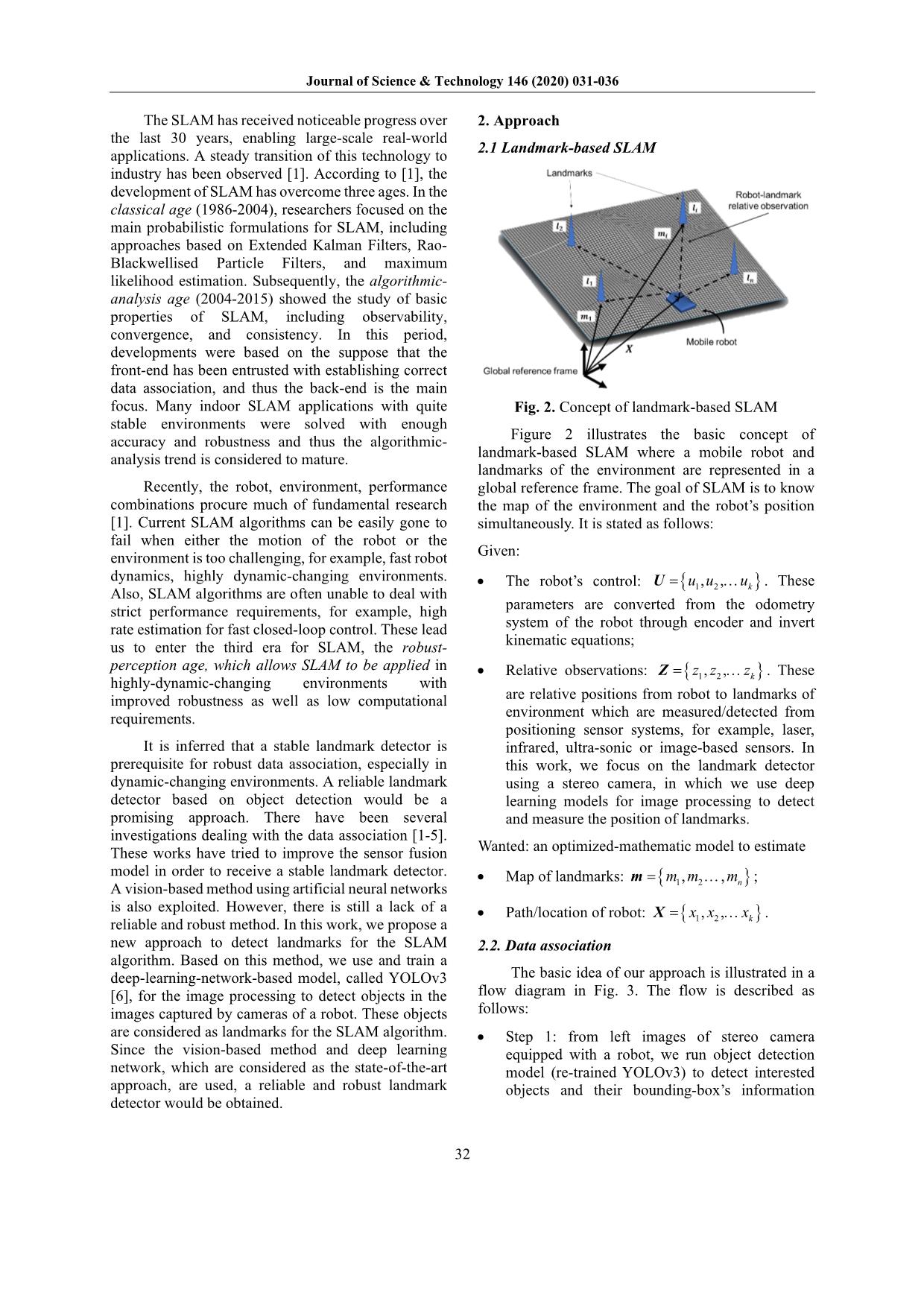
Fig. 2. Concept of landmark-based SLAM
Figure 2 illustrates the basic concept of
landmark-based SLAM where a mobile robot and
landmarks of the environment are represented in a
global reference frame. The goal of SLAM is to know
the map of the environment and the robot’s position
simultaneously. It is stated as follows:
Given:
• The robot’s control: { }1 2, , ku u u= U . These
parameters are converted from the odometry
system of the robot through encoder and invert
kinematic equations;
• Relative observations: { }1 2, , kz z z= Z . These
are relative positions from robot to landmarks of
environment which are measured/detected from
positioning sensor systems, for example, laser,
infrared, ultra-sonic or image-based sensors. In
this work, we focus on the landmark detector
using a stereo camera, in which we use deep
learning models for image processing to detect
and measure the position of landmarks.
Wanted: an optimized-mathematic model to estimate
• Map of landmarks: { }1 2, , nm m m= m ;
• Path/location of robot: { }1 2, , kx x x= X .
2.2. Data association
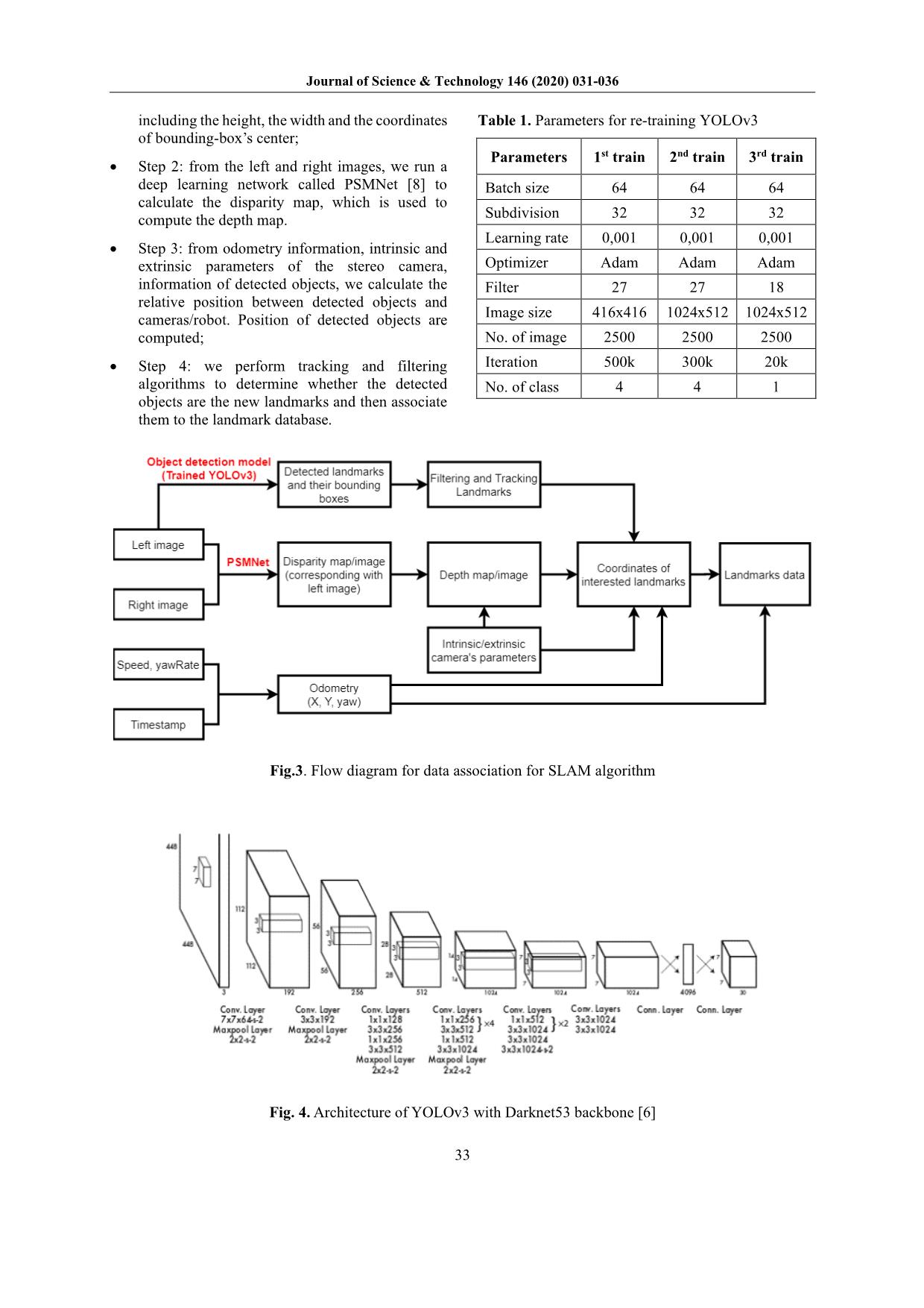
The basic idea of our approach is illustrated in a
flow diagram in Fig. 3. The flow is described as
follows:
• Step 1: from left images of stereo camera
equipped with a robot, we run object detection
model (re-trained YOLOv3) to detect interested
objects and their bounding-box’s information
Journal of Science & Technology 146 (2020) 031-036
33
including the height, the width and the coordinates
of bounding-box’s center;
• Step 2: from the left and right images, we run a
deep learning network called PSMNet [8] to
calculate the disparity map, which is used to
compute the depth map.
• Step 3: from odometry information, intrinsic and
extrinsic parameters of the stereo camera,
information of detected objects, we calculate the
relative position between detected objects and
cameras/robot. Position of detected objects are
computed;
• Step 4: we perform tracking and filtering
algorithms to determine whether the detected
objects are the new landmarks and then associate
them to the landmark database.
Table 1. Parameters for re-training YOLOv3
Parameters 1st train 2nd train 3rd train
Batch size 64 64 64
Subdivision 32 32 32
Learning rate 0,001 0,001 0,001
Optimizer Adam Adam Adam
Filter 27 27 18
Image size 416x416 1024x512 1024x512
No. of image 2500 2500 2500
Iteration 500k 300k 20k
No. of class 4 4 1
Fig.3. Flow diagram for data association for SLAM algorithm
Fig. 4. Architecture of YOLOv3 with Darknet53 backbone [6]
Journal of Science & Technology 146 (2020) 031-036
34
2.3. Landmark detection
You Only Look Once (YOLO) is a state-of-the-
art, real-time object detection model. It processes
images at very high speed accompanied by a high rate
of accuracy of 57,9% at IoU of 0,5 on COCO dataset.
As showed in Fig. 4 YOLOv3 is developed basing on
Darknet-53 neural network which consists of 53
convolutional layers. In this work, we exploit a
pretrained model of YOLOv3 [6] and perform fine-
tuning the model to obtain the best-fitted model.
Toward applications for autonomous driving, we use
the so-called Cityscapes dataset [7] for re-training the
pre-trained model. The Cityscapes dataset is an open-
source dataset, containing 5000 annotated images with
fine annotations captured by the stereo camera
installed on a car with a high-accuracy GPS system.
Fig. 5. Image of Cityscapes dataset with bounding
boxes of interesting objects [7]
The dataset has 30 classes of objects in traffic
infrastructure and road. In this work, we consider only
poles, traffic lights, traffic signs as landmarks for the
SLAM algorithm. Therefore, we build a program to
refine the dataset keeping only interesting objects.
Fig.5 shows an example of images having interesting
objects accompany with their bounding box. We re-
trained the model on a high-performance server with 4
GPUs Pascal Titan X. The configuration of the training
parameters is shown in Table 1.
2.4. Landmark localization
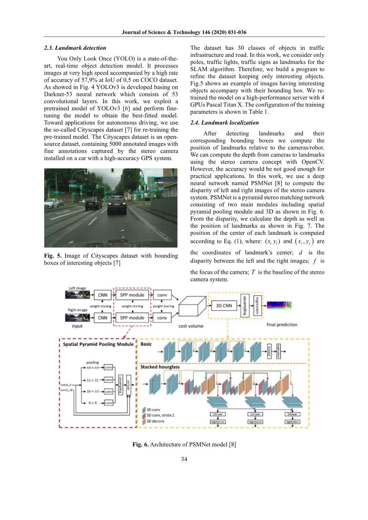
After detecting landmarks and their
corresponding bounding boxes we compute the
position of landmarks relative to the cameras/robot.
We can compute the depth from cameras to landmarks
using the stereo camera concept with OpenCV.
However, the accuracy would be not good enough for
practical applications. In this work, we use a deep
neural network named PSMNet [8] to compute the
disparity of left and right images of the stereo camera
system. PSMNet is a pyramid stereo matching network
consisting of two main modules including spatial
pyramid pooling module and 3D as shown in Fig. 6.
From the disparity, we calculate the depth as well as
the position of landmarks as shown in Fig. 7. The
position of the center of each landmark is computed
according to Eq. (1), where: ( )l lx y and ( ),r rx y are
the coordinates of landmark’s center; d is the
disparity between the left and the right images; f is
the focus of the camera; T is the baseline of the stereo
camera system.
Fig. 6. Architecture of PSMNet model [8]
Journal of Science & Technology 146 (2020) 031-036
35
Fig. 7. Drawing of computation of landmark’s position
; ; ;P P l P l l r
T T TZ f X x Y y d x x
d d d
= = = = − (1)
Fig. 8. Result of landmark detection with trained
YOLOv3
Fig. 9. Computation of pole positions as landmark
using YOLOv3 and PSMNet
3. Results and discussion
We performed three trainings for YOLOv3 with
parameters listed in Table 1. We choose four types of
objects as landmarks including poles, traffic lights,
traffic signs, buildings. With the first training, we have
the Intersection over Union (IoU) only 50-60% at the
iteration of 50k. The reason would be the size of
inputted images is too small of 416x416 pixels leading
to loss of information when scaling.
In the second training, we increased the size of
images to 1024x512 pixels and obtain much better
results with IoU rate as high as 80-90% and a precision
of 91-99%. As exemplarily shown in Fig. 8, the re-
trained model works qualitatively well where almost
all poles, traffic lights, traffic signs, and buildings are
detected with a high rate of IoU.
For the third train, we considered only pole and
configured the filter to 18. The result does not show a
better result. Therefore, we use the result of the second
training covering more types of objects.
To validate PSMNet we use an open-source
dataset named KITTI [9] for the comparison. The
KITTI dataset has many images accompanied by laser-
based measurement, where the relative position from
robot/laser-based sensors to objects in captured images
is measured. The poles can be considered as landmarks
for practical applications.
Fig. 9 shows exemplarily the computation of pole
positions using our proposed method. The results are
then compared with laser-based data of KITTI dataset
as shown in Table 2.
It is seen that the discrepancy between the depth
from our method and the depth from laser-based
measurement is small. Especially, when the distance is
smaller than 30m the PSMNet-based results match
very well with the laser data. This can be explained
that, with objects lying within the distance below
Journal of Science & Technology 146 (2020) 031-036
36
30 m, the quality of the pixels is quite good to be
inferred. Over this range the results cannot be
believed; The error increases to 20%. With a distance
further than 30m, the calculation is not exact anymore.
In practice we have the tracking and filtering algorithm
for landmarks, therefore we do not need to detect and
localize landmarks which are very far from the robot.
As a result, landmarks in the distance below 30m can
be used. Thus, our method can be used efficiently in
practice with a high rate of reliability and accuracy.
Since we use the vision system, the ambiguity of the
environment which usually happens with the laser
system can be eliminated.
Table 2. Validation of depth computed by our method
and laser-based measurement data
Laser-based
measurement
data (m)
Depth computed
by our method
(m)
Discrepancy
(%)
6,872 7,12 1,86%
8,863 9,03 1,55%
13,761 14,23 1,74%
22,786 23,143 1,57%
24,033 23,143 -3,70%
30,293 27,98 -7,64%
37,108 33,98 -8,43%
43,748 38,163 -12,77%
59,793 46,531 -22,18%
71,019 56,224 -20,83%
4. Conclusions
In this paper, we have presented a new approach
to detect and localize landmarks for the landmark-
based SLAM algorithm using deep neural networks for
processing images. The YOLOv3 and PSMNet were
trained and exploited for the issue of object detection
and object localization. Our method shows
qualitatively high quality both in the capacity of
landmark detection and landmark localization where
the average IoU and precision are as high as 80-90%
and 91-99%, respectively. Our method can be used for
a vision-based SLAM system, where landmarks in a
distance of below 30m can be detected and localized at
a very high rate of accuracy. The results of this work
are good bases for further research in the future. This
would be a hot research topic for the community of
mobile robot scientists in the era of artificial
intelligence with deep neural networks.
In the future, we will continue improving our
model and transfer the result to a real system toward
the practical application of autonomous driving.
Acknowledgements
This research is funded by Hanoi University of
Science and Technology (HUST) under project
number TC2018-PC-022.
References
[1] C. Cadena, L. Carlone, H. Carrillo, Y. Latif, D.
Scaramuzza, J. Neira, I. Reid, J. J. Leonard. Past,
Present, and Future of Simultaneous Localization and
Mapping: Toward the Robust-Perception Age. IEEE
Transactions on Robotics, 32(6): 1309 – 1332, 2016.
[2] Y. Latif, C. Cadena, and J. Neira. Robust loop closing
over time for pose graph slam. The International
Journal of Robotics Research (IJRR), 32(14):1611–
1626, 2013.
[3] N. Suenderhauf and P. Protzel. Towards a robust back-
end for pose graph SLAM. In Proceedings of the IEEE
International Conference on Robotics and Automation
(ICRA), pages 1254–1261. IEEE, 2012.
[4] F. Zhong, S. Wang, Z. Zhang, C. Zhou, and Y. Wang.
Detect-SLAM: Making Object Detection and SLAM
Mutually Beneficial. IEEE Winter Conference on
Applications of Computer Vision, 12-15 March 2018.
[5] S. L. Bowman, N. Atanasov, K. Daniilidis and G. J.
Pappas. Probabilistic Data Association for Semantic
SLAM. 2017 IEEE International Conference on
Robotics and Automation (ICRA) Singapore, May 29
- June 3, 2017.
[6] https://pjreddie.com/darknet/
[7] https://www.cityscapes-dataset.com/
[8] Chang, J. R., & Chen, Y. S. (2018). Pyramid Stereo
Matching Network. Proceedings of the IEEE
Computer Society Conference on Computer Vision
and Pattern Recognition, 5410–5418.
https://doi.org/10.1109/CVPR.2018.00567
[9]
enchmark=depth_completion
File đính kèm:
 a_new_landmark_detection_approach_for_slam_algorithm_applied.pdf

